Showing posts with label Palo Alto. Show all posts

28 October 2022

News Roundup, October 2022

CBOSS Dumpster Fire Update: the CBOSS case is still making its way through San Mateo County Superior Court (under case file 17CIV00786). The trial was held in April through June of this year, and closing briefs are due in December. Closing arguments are currently scheduled to be made in court on the 5th of January 2023. The latest kerfuffle is over a post-trial Caltrain/Parsons motion to seek punitive damages from Alstom for intentionally, not just negligently, lying about the status of the project based on testimony given during the trial.

Trains Without Wires: Caltrain held a VIP invitation-only unveiling of the new EMUs in San Francisco on September 24th. Four trainsets (serial production #2 - #5) have now been delivered and will collect dust (graffiti?) for a couple of years because the electrification of the corridor is far from done. The new trains were hauled to San Francisco by diesel power.

New Palo Alto downtown
grade separation

Stirring Things Up In Palo Alto: Caltrain recently briefed the city on their plan to replace the ancient bridge over the San Francisquito Creek. This is precipitating a sudden change to the city's years-long policy of kicking the can down the road on what to do about a future grade separations at downtown Palo Alto. While everybody seems to assume the bridge and grade separation projects are necessarily linked, they are not! The solution is pretty darn obvious: replace the Palo Alto Ave crossing with a new grade separation at Everett Ave, which would connect downtown to El Camino as shown in the sketch at right.

  1. Permanently close and demolish the Alma bridge over University Ave, instead connecting Alma to University via the existing cloverleaf ramps reconfigured as a signalized intersection.
  2. Build a new downtown elevated grade separation viaduct and platforms through the existing station parking lots, along the original track alignment that existed before the University Ave grade separation was opened in 1940. This viaduct would be open underneath, providing station parking, bus platforms, pick-up/drop-off areas, and other station amenities. Bonus: the new straightened track alignment removes a speed-limiting double reverse curve in the tracks.
  3. Cut over the trains to the new viaduct and elevated station. 
  4. Extend Everett Ave under the elevated tracks to the existing intersection at El Camino Real and Quarry Rd, also picking up a new connection to the convoluted and inefficient bus loop. Bonus: bus service is greatly sped up to/from El Camino, Stanford and downtown by avoiding time-consuming looping routes.
  5. Permanently close the grade crossing at Palo Alto Ave.
  6. Demolish the old University Ave rail bridge, remove the old cloverleaf ramps, and bring the University Ave / Alma intersection back up to a grade level signalized intersection.

This grade separation approach is completely decoupled from whatever happens with the San Francisquito bridge.

More CEQA Lawsuits Flying: the recent certification of the HSR San Francisco to San Jose EIR precipitated several new CEQA lawsuits. Brisbane and a private developer are upset about the sprawling HSR "light" maintenance facility planned in the city, and its impact on the planned Brisbane Baylands development. Millbrae also got in on the action due to a clash between its development plans and the planned expansion of the station footprint for HSR. Unfortunately, the Sacramento Superior Court does not allow free access to case files, so details are hard to obtain.

24 January 2019

Palo Alto: Designing in a Vacuum

Palo Alto is continuing the fraught public process of winnowing down the feasible and acceptable options for grade separating the four remaining rail crossings. Having hired an engineering consultant, the city is busily making plans for railroad land that doesn't belong to it and over which it has no jurisdiction.

The fancy renderings from a recent meeting, envisioning a tunnel, a trench, a hybrid embankment, or a viaduct, invariably show expansive new landscaping when construction is finished. This is reflective of the ample railroad land available through most of Palo Alto. Caltrain's land is typically about 100 feet wide, excepting a few short sections of the corridor near Southgate and Peers Park that are just 60 feet wide. South of those narrow spots, there is plenty of room to accommodate four tracks (about 75 feet required) if needed in the future, no matter what the pot-stirring local press may say.

Palo Alto's planning process thus far seems to have missed these important facts:

  1. Caltrain's nascent business plan envisions ambitious expansions of service in the next two decades, growing far beyond the initial goal of electrification. Service planning thus far strongly suggests (pp. 64-67) that new overtake tracks will be needed approximately from south of Peers Park to the Mountain View border. The additional tracks in south Palo Alto, featured in all remaining options (p. 34), would allow express trains to pass local trains.
     
  2. In other cities to the north and south where Caltrain has become directly involved in the planning process, it has levied a requirement that city-generated grade separation designs preserve the future option of adding overtake tracks, expanding the corridor from two to three or four tracks. Two examples:
     
    • Whipple Ave in Redwood City, where the city recently hired Caltrain to lead the planning effort. On page 138 of the October 1st, 2018 city council meeting agenda, a letter from Caltrain states: "... the Project Study Report must include at least one design option that accommodates the potential overtake. In this context, "accommodate" is understood to have the following minimum threshold of meaning: the grade separation design maximizes the preservation and configuration of existing right of way such that overtake tracks could be built later with no or minimal right of way acquisition; the grade separation design does not force future overtake tracks to be built in a way that substantially increases their cost and complexity."
       
    • Rengstorff Ave in Mountain View, where the city recently hired Caltrain to lead the preliminary engineering and environmental clearance effort. On page 105 of the December 2018 JPB board meeting agenda, we read that "the design will consider and accommodate Caltrain / high-speed rail blended system improvements and be designed to allow for up to four tracks."
In practical terms, this adds a new constraint to Palo Alto's grade separation deliberations. We can reasonably infer that Caltrain will require at least the Charleston / Meadow grade separation to be engineered for four tracks, or at least not to preclude four tracks. The sooner this constraint is incorporated into the city's planning process, the less anguish and recrimination there will be in arriving at an acceptable design.

When planning construction on someone else's land, it helps to know what the owner wants.

26 September 2017

Thoughts on Palo Alto

There is a vigorous discussion of grade separations now underway in Palo Alto. It misses several important points:

1) Grade Separation is not one project. Trying to come up with a single, grand unifying grade separation scheme for the entire rail corridor through Palo Alto is to over-constrain the problem and to limit the range of feasible solutions. The wide geographical spacing of the four remaining grade crossings in Palo Alto leads naturally and logically to three separate and independent projects: Alma, Churchill, and Meadow/Charleston. These three projects can be and should be completely decoupled from an engineering perspective, if not from a political perspective. The underlying geometry of Palo Alto does not lend itself to a single project.

2) Creating new cross-corridor access is not grade separation. While it is understandable that the city desires to knit together neighborhoods on opposite sides of the track by creating new places ("trench caps") where people can access the other side of the corridor, this is not grade separation and should not be funded by scarce grade separation or transportation dollars. It can't be said that the city was actively divided by the rail corridor, since the rail corridor was in place decades before Palo Alto grew into a city. While everyone agrees that new cross-corridor access would improve Palo Alto, the distinction of scope between grade separation of existing crossings (today's network topology) and new cross-corridor access (tomorrow's network topology, a nice-to-have) should remain crystal clear. Muddling the project scope will muddle the discussion of funding.

3) Split-grade solutions should be studied with due diligence. When the city commissioned a grade separation study from engineering firm Mott Macdonald, the council deliberately excluded from consideration any designs where rails or roads might rise above existing grade. From the outset, this eliminated the standard solution that every other peninsula city has adopted: San Bruno, Burlingame, San Mateo, Belmont, San Carlos, Menlo Park and Sunnyvale either already have or are planning split grade separations, where the rails are raised a bit and the streets are lowered a bit. Turning a blind eye to split grade solutions, however controversial they may be, casts doubt on the entire decision making process. Without due diligence in studying a full range of grade separation solutions, the politics of assembling the necessary funding will become unnecessarily complicated.

4) Funding matters. The most expensive options are the most popular because the cost isn't yet borne by anyone. Everything is paid for with OPM or Other People's Money. If you went to a restaurant with OPM, of course you would select the Filet Mignon (or truffles, if you're vegetarian). A selection process that ignores funding is detached from reality. This also means teaching people about orders of magnitude: capturing ill-defined revenue from new uses of 45 acres of highly impaired land that the city doesn't own, even at Palo Alto prices, doesn't begin to pay for the astronomical expense of burying the tracks. Until funding is seriously factored into decision making, it's all just unicorns and rainbows.

5) County grade separation funding is always at risk. While 2016 Measure B set aside $700 million for grade separation projects, a 3/4 majority vote of the VTA board is all that it takes to re-program some or all of that funding "as circumstances warrant" towards BART, in the exceedingly likely event that the San Jose extension goes over budget. Spend it soon, or flush it into a giant sink hole in San Jose.

Failing to properly acknowledge these realities will likely leave Palo Alto's decision making process tied in knots as other cities move forward.

29 December 2012

Grade Separation: The Decadal View

For the last few years of debate around the issue of high-speed rail, grade separating the peninsula rail corridor was often cast as an all-or-nothing proposition.  This extremist view clouded two important facts: first, the corridor is already mostly grade-separated (in 2013, only 40 road crossings out of 104 between San Francisco and San Jose will remain at grade); and second, grade separation is a slow and inexorable process that takes place over many decades.

If we assume the next several decades will be like the last several decades, we can take an educated guess about how and in what order grade separations will be built.  The criteria for prioritizing each project could be:
  • creating long, uninterrupted stretches of grade separated right of way to enable higher train speeds without compromising safety
  • creating a four-track mid-line overtake facility to increase the capacity of the corridor, to support initial HSR service
  • separating crossings that rank highest in the CPUC's Section 190 Grade Separation Priority List
  • delaying the most expensive and politically costly projects until last
Phase I is simply the completion of the San Bruno grade separation in 2013.  The San Mateo / San Bruno grade crossing being replaced was once rated #7 statewide on the CPUC's priority list.

Phase I: San Bruno Grade Separation

Phase II consists of four projects in San Mateo County, opening up two long stretches free of crossings by the early 2020s, including 14.8 miles free of crossings north of Burlingame, and 6.5 miles south of San Mateo.  This enables the future construction of the "short" mid-line overtake envisioned in Caltrain's corridor capacity analysis, and leaves only a few dense clusters of crossings within San Mateo County.  The new grade separations, in order of priority, are:
  1. 25th Ave in San Mateo, the only grade crossing that remains between San Mateo and Redwood City.  Along with new grade separations already planned at 28th and 31st, this project enables the future 4-track mid-line overtake.
  2. Broadway in Burlingame, an extremely congested crossing that has been slated for grade separation since the 1970s.  It rates #11 statewide on the latest CPUC priority list.
  3. Linden Ave in South San Francisco, originally planned as part of the San Bruno project, but dropped from the final design in 2007.  Grade-separation at Linden is accompanied by the closure of Scott St, which becomes a pedestrian tunnel.
  4. Center Street in Millbrae, a grade separation that will require a U-shaped elevated ramp due to the nearby BART subway tunnel box.  Such are the consequences of bad planning.
Each of these projects is independent and can be negotiated on a case-by-case basis with the four affected cities.  Starting in San Mateo County allows at least another decade for the Pacheco vs. Altamont debate to run its due course, legally and politically; these four projects are useful either way.

Phase II: San Mateo County Grade Separations
Phase III occurs mostly in Santa Clara County, creating a new stretch free of grade crossings from the southern half of Palo Alto all the way to San Jose in the late 2020s, assuming the routing of HSR over Pacheco survives as currently planned.  The last two grade crossings in San Francisco are also eliminated as part of the downtown extension project.  This phase includes the following six discrete projects:
  1. Mary Ave in Sunnyvale, the corridor's busiest grade crossing in this county, with more than 25,000 daily vehicles
  2. Sunnyvale Ave
  3. Rengstorff in Mountain View, with about 18,000 daily vehicles
  4. Castro in Mountain View, with about 9,000 daily vehicles
  5. Charleston and East Meadow in Palo Alto, with a combined ~30,000 daily vehicles plus numerous pedestrians and bicyclists
  6. 16th and Common in San Francisco, as part of the DTX project
Together, these six projects create a new 16-mile stretch of track that is entirely free of grade crossings.  The corridor is now left with just three dense clusters of grade crossings, in San Mateo / Burlingame, Redwood City, and PAMPA (Palo Alto - Menlo Park - Atherton), highlighted in orange in the figure below.  Note that these three dense clusters contain 27 crossings, and that to get this far, only 12 existing crossings were newly separated.

Phase III: Santa Clara County Grade Separations
Phase IV is the Great Redwood City Grade Separation.  This project, potentially for the early 2030s, would prolong the four-track mid-line overtake by three miles, by removing six grade crossings in downtown Redwood City.  Removing this cluster first makes sense from the standpoint of increased corridor capacity, the lowest number of new structures, the short mileage, and the entire project being politically simplified by virtue of its containment within Redwood City limits.

Phase V is the Great San Mateo / Burlingame Grade Separation.   This is a tougher project because it involves some of the most highly constricted portions of the corridor.  It also involves political and technical coordination between two neighboring cities, adding an additional challenge.  The sheer quantity of crossings (13 grade crossings + 4 obsolete grade separations within 2.4 miles) is also a complicating factor.

Phase VI is the Great PAMPA Grade Separation.  This project is left for last because it lies in the most expensive real estate on the corridor, involves coordination between three different cities, and is liable to cause the fiercest political and legal backlash anywhere on the peninsula.  Delaying it until last, perhaps into the late 2030s, allows the customarily long planning process to run its course without undue haste in all three affected communities.

We didn't arrive at today's state of grade separation (more than half) overnight.  It resulted from a slow and steady process that began in earnest in the 1940s.  The future is likely to be similar, and the peninsula rail corridor can reach a far improved state by separating just 12 more crossings over the next couple of decades, as described in Phases II and III.  This dozen should be prioritized for construction, before any of the crossings in the remaining dense clusters are touched.

16 February 2010

Trains or the Tree

The Palo Alto Daily Post, a free print-only publication than never misses a muckraking opportunity to drum up advertising dollars, is stepping up its HSR fear-mongering another notch. Just like it did one year ago, the Post headline blares: It's Trains Or the Tree. Fast rail will doom fabled redwood.

That's right, 1070-year-old El Palo Alto, California Historical Landmark No. 2, is on the chopping block again.

Palo Alto arborist Dave Dockter is quoted as saying "The best scenario for the tree would be no rail project. The second best would be to tunnel way down deep under the tree so as to not mess up its roots and the hydrology, but there couldn't be an above-ground scenario near the tree; that would be catastrophic."

The rest of the article suggests that Dockter may have been shanghaied into this sensational story. He goes on to say that if anything can be done to save the tree, it will have to spring from a determined joint effort between rail officials and tree experts. "All the nation's best arborists and engineers would have to come around that tree and be on the same side, not as an adversarial relationship, but as an engineering challenge. Engineering needs to meld with nature."

Well, duh.

Just like a year ago, the relevant facts on this issue remain the same:
  • The right of way is nearly 150 feet wide at El Palo Alto
  • The existing rail bridge over the San Francisquito Creek, built in 1904 at the base of the tree, will need replacement soon even if HSR isn't built
  • The Daily Post often confuses Page One with its editorial page
This provides yet another reason for the project to hire an arborist. If Dockter had a counterpart, he might not be so inclined to let the Daily Post to stir the HSR pot. In the meantime, there can be little doubt that engineers and arborists will eventually see to it that El Palo Alto is safe.

05 December 2009

Elevated Obsession

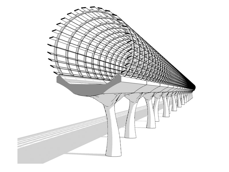
Another creative proposal (see also PDF brochure) has emerged from Palo Alto architect Joseph Bellomo, this time for an elevated high-speed rail line built down the middle of the Caltrain right of way, partially enclosed in a tubular structure with sound baffles, solar panels, and if one believes the sketches, optional LED lighting. More broadly, Bellomo is calling for an international design competition to come up with the best world-class design; he laments that the design has so far been dominated by teams of engineers working separately on each segment of the line.

Design is nice, but what about engineering function? For something as utilitarian as rail transportation infrastructure, function obviously trumps form. That inevitably leads one to ask the most obvious question about Bellomo's concept.

Why Elevate?

It is a useful exercise to identify the reasons for elevating the tracks.
  1. because it looks sexy and futuristic, just like the Disneyland monorail or other gadgetbahn concepts like maglev or Tubular Rail. These are so often depicted on elevated guideways that elevation itself has become associated with modernity and speed. The average American, who has little or no exposure to high-speed rail, is especially vulnerable to this pop-culture association--and it's a terrible reason to build elevated tracks.

  2. because it allows the tracks to collect solar energy, as envisioned by Bellomo. Solar panels sure are green and trendy, but they are far from proven as an optimal way to power a peaky and very high electrical load (a single accelerating train can draw about 10 megawatts). If renewable energy is used to power the trains, its source should be a choice that is not locked in by design of the infrastructure. The problem of powering the trains is adequately decoupled (through the electrical grid) from the problem of how to generate the power.

  3. because of a need to fit more tracks into a constrained right of way. If you can't spread out horizontally, then go vertical. Again, this is a solution to a problem that mostly doesn't exist on the peninsula: the vast majority of the railroad right of way, including the portion through downtown Palo Alto, has ample width for as many tracks as would ever be required to provide both commuter and HSR services. Even in those few locations that are constrained, acquiring additional land is far cheaper than the construction cost and ongoing maintenance cost of elevated structures or tunnels. That available width is why they chose the Caltrain corridor in the first place. Where Bellomo's renderings show an elevated across University Avenue, the railroad right of way is over 160 feet wide!

  4. because it provides unimpeded access from one side of the tracks to the other for pedestrians, bicycles and motor vehicles--something that is better known as grade separation. This is the only good reason ever to elevate the tracks. Unfortunately, the Bellomo proposal falls short on this as well: the existing commuter tracks stay at grade, forming the same community barrier that they already are today. Worse, elevating HSR over Caltrain would severely curtail the options for later removing grade crossings.
Of course, there are plenty of valid reasons not to elevate the tracks, including noise, shadow, visual blight, expense, safety (passenger evacuation) and operational flexibility.

Missing the Point

While Bellomo's HSR concept has obviously been polished from an architectural design standpoint, the basic premise of an elevated HSR is not rooted in any realistic functional or engineering need. That flaw makes Bellomo's complaints that engineers are in charge ring a bit hollow.

While he can be lauded for proposing fresh solutions, Bellomo clearly needs to review his concept with civil engineers who have direct experience with high-speed rail infrastructure. (Hint: there are precious few of them in California.) In the meantime, we can easily state...

The Three Rules of Elevation
  1. Don't elevate the tracks if you can avoid it.
  2. If you can't avoid it, then elevate solely to provide access from one side of the tracks to the other, i.e. grade separation, and return to ground level as quickly as possible.
  3. Keep all tracks at the same elevation, to provide operational flexibility--allowing trains to easily switch from one track to another as dictated by operational service needs.

16 August 2009

Palo Alto Innovates

While the city of Palo Alto has of late developed a certain ambivalence towards high speed rail, some residents are taking the planning into their own hands. Taking for granted that high speed rail will come through Palo Alto, a group of civic leaders and architects is elaborating some design proposals that may shape the California High Speed Rail Authority's ongoing analysis of alternatives.

The group proposes tunneling the train tracks through the entire 4 mile (6 km) length of Palo Alto, as first described in a Palo Alto Weekly cover story published before the 2008 election. This idea, which would liberate more than 40 acres of land currently owned and occupied by the railroad, has since been fleshed out into an urban design concept entitled Innovation Place. A presentation of Innovation Place earned the group a 2009 urban design award from the American Institute of Architecture California Council. As its creators note, Innovation Place is a collection of ideas rather than a specific project proposal.

The crown jewel of Innovation Place is a complete transformation of the University Avenue station area, as envisioned in the team's graphic above. High speed rail or not, this area of Palo Alto is in dire need of a redesign; today, access between three important zones of activity (the University Avenue shopping district, Stanford University, and the Stanford Shopping Center) is a circuitous and dysfunctional jumble that is both unpleasant and time consuming to navigate, whether by foot, bike, car or bus. Neighboring areas just a few hundred feet apart feel miles away from each other.

The remainder of the Innovation Place proposal consists of a 31-acre linear park adjoining Alma Street, featuring a bike and pedestrian path and uniting the two halves of Palo Alto formerly separated by the train tracks. The additional cost of putting the tracks underground would be financed by selling $700 million worth of air rights for development.

Tunnel Financing

The feasibility of the Innovation Place concept hinges on the financing for tunnel construction. Will air rights for residential and commercial development really be worth $700 million? Will Palo Alto's famously difficult development approvals process allow the construction of 660 homes and 814,000 sq ft of retail and the elimination of El Camino Park, Palo Alto's oldest public park? Will the incremental cost of tunnels (as compared to simpler track alignments) cost as little as $700 million?

These questions remain unanswered, and the technical challenges of building a cavernous four-track high-speed tunnel might not bode well for the cost. On simple grounds of environmental justice, the CHSRA has refused to contribute its own funding for any tunnels that benefit a local community rather than provide added transportation functionality. Instead, it encourages cities to pay for such tunneling costs, as Berkeley did with BART in the 1960s. That scenario might require Palo Alto to pay for the project by taxing itself through an initiative passed at the polls. For such an initiative to have even the slightest chance of passing, the benefits need to be distributed throughout Palo Alto, and not just be focused on the University Avenue area. That is why, out of political necessity, the linear park along the entire length of Palo Alto is a non-negotiable component of the concept. A partial tunnel just won't do.

The city of Palo Alto recently set aside $70,000, in large part for hiring an engineering consultant to provide independent review of tunneling plans. The consultant is Hatch Mott MacDonald, a mega-firm with extensive tunneling experience (and one of the key players in San Francisco's Downtown Extension project) that has previously provided advice to the backers of the Innovation Place concept. While such a consulting arrangement may be independent of the CHSRA, the firm does have an incentive to show financial feasibility of a tunnel because it may well end up bidding on its construction--a conflict of interest that should be mitigated to obtain the most objective evaluation of tunneling options.

Does It All Hang Together?

If Innovation Place has a weakness, it is that the concept really consists of two separable elements: the University Avenue redevelopment, and the tunnel / linear park. If Palo Alto were to become a high speed rail stop, the rare opportunity to reconfigure and redevelop the station area would present itself regardless of whether or not the tracks ran in tunnels. Most of the Innovation Place presentation is devoted to this intelligent urban re-design of the University Avenue area, which has great merit on its own.

On the other hand, the tunnel and linear park need the University Avenue development in order to make even the slightest bit of sense; otherwise, what's left is a billion-dollar public park, an idea that obviously won't get very far.

Beyond Innovation Place

One of the key features of Innovation Place is an underground station at University Avenue. However, it's worth considering an even wider range of options: this area could just as well be redeveloped without any tunnels at all. Streets on either side of the tracks could be reconnected using regular grade separations. Lytton Street could be connected to the bus depot, El Camino and Quarry Road, improving bus, shuttle and taxicab connections at the train station.

The station platforms could even be elevated with a large pedestrian and transit plaza underneath, in the manner of Amsterdam's spectacular Bijlmer Arena station, a project that has won several architectural awards. Bijlmer was designed by Grimshaw Architects and completed in 2007 for 130 million euros. (Photo by tataAnne; view more photos.) While it is about double the size that Palo Alto would ever need, its design philosophy is light years beyond the unpleasant and unsafe walk through the 1940s University Avenue underpass:
Every aspect of the design process was informed by the need to civilise the viaducts and to create a pleasant and safe ground level public space. To avoid a dark 100 m long tunnel, the concrete structures were spaced apart. Each 20 m span was supported at each end on just one column via an integrated cantilevered saddle. Arrays of columns were then aligned on axis with the boulevard to maximize visual connectivity from east to west. However, the most important decision concerned the roof design in general and its soffit treatment in particular. It is the modulation of this surface, its ribbons of roof glazing and its acoustically absorbent Oregon pine surfaces that convey civility from the perspective of the boulevard below. [From the Grimshaw website]
If one thing is sure, there is no shortage of architectural possibilities--with or without tunnels.

Looking Ahead, Not Back

Palo Alto is unleashing its creative talents on how best to weave high speed rail into the fabric of the city. The city will be hosting design "teach-in" on September 12th, sponsored by the Peninsula Cities Consortium. On October 3rd and 4th, the creators of Innovation Place will host a high speed rail workshop geared towards developing solutions and tangible design products for use in the CHSRA's analysis of alternatives, a key document that will be published by the Authority by the end of this year. Legislators, civic leaders, Caltrain and the CHSRA will participate in both events.

Whatever quibbles one may have with Innovation Place, it represents a forward-looking vision for Palo Alto and an embrace of high speed rail, rather than a desperate clinging to the past, and for that alone, it is refreshing.

Full disclosure: this blogger may participate in these events.

03 June 2009

Crass NIMBYism

Last night, for the second time in a month, a 17-year-old Palo Alto Gunn High School student committed suicide by Caltrain at the Meadow Drive grade crossing.

Not even 24 hours later, Palo Alto HSR opponents are turning this tragedy into another tunnel-or-nothing rant. On the Palo Alto Online forums, one of the leaders of the Palo Alto anti-HSR group expounds:
Lets not let these two poor kids have died in vain (plus the ones last year, year before, year before that, and on and on..) I think it would be a very powerful message to Obama administration, FRA, and California legislators if the kids banded together to write letters or something asking for laws to require the trains to be undergrounded, kept out of neighborhoods. (...)

If they can't get the trains out of here all together (which they probably can't, or won't), they need to put them underground, sealed off and away from access to cars, pedestrians, bikes. Fences along the tracks are going to be useless to prevent people, especially kids, who have the intention of using trains for this purpose.
This is wrong on so many levels.
  • Using this tragedy so soon to advance a long-held tunnel-or-nothing agenda is opportunistic in the extreme, and betrays a profound lack of respect for the victim and those she left behind

  • Implying that trains routinely kill children and using kids in letter-writing campaigns deliberately sidesteps the root cause of these tragic events

  • Downplaying the fact that the California High Speed Rail Authority has plans to grade-separate this crossing--a measure nearly as effective as tunnels for safely separating trains from pedestrians--and demanding tunnels as the only secure solution is intellectually dishonest

  • On a cost-benefit basis, demanding tunnels that cost hundreds of millions more than the proposed grade separation, in an attempt to save the lives of suicidal pedestrians, is an enormous waste of money that could save many more lives if spent more wisely.
My apologies for the temporary deviation from more substantive blog material. May she rest in peace.

23 May 2009

The Shape of Palo Alto

Several years ago, the city of Palo Alto commissioned a public art work entitled The Color of Palo Alto. At considerable expense ($75,000), artist Samuel Yates set out on a techno-artistic quest to determine the exact shade of Palo Alto. In a similar vein, and bearing in mind that artistic form is more than just color, we set out to determine the shape of Palo Alto.

Why does the shape matter? While the area around the tracks in Palo Alto is pretty flat, small variations in the terrain do have an effect on how the high speed rail project will be configured as it crosses through town. The vertical alignment of the tracks must not only conform to the surrounding grade, but it must be routed over or under every creek, road, pedestrian or bike crossing while conforming to acceleration limits imposed by passenger comfort as well as train stability and performance.

There have already been strong hints as to what shape this vertical alignment might take, as previously discussed in Focus on Palo Alto. As part of its program-level EIR/EIS, the California High Speed Rail Authority produced a set of maps of the Caltrain corridor that fueled a firestorm of controversy in Palo Alto, with residents worried that raised tracks would form a Berlin Wall and divide the city. While the CHSRA now professes to consider all vertical alignment options for its project-level EIR/EIS, ranging from tunnels to elevated tracks, there aren't that many feasible and affordable ways to design the vertical alignment of HSR tracks through Palo Alto-- and it turns out that the shape of Palo Alto can tell us a lot about what those are.

Working from Caltrain track survey data, here is the shape of Palo Alto, with the vertical scale greatly exaggerated: (click to expand)


 Note a few salient features:
  • Palo Alto isn't as flat as you might think. Who knew that the University Ave station is nearly 40 feet higher than the California Ave station?
  • There are only four grade crossings in all of Palo Alto
  • Including overpasses, underpasses and grade crossings, there are only nine places where pedestrians and bikes may cross the tracks in all of Palo Alto, and only seven places where roads cross the tracks
  • The entire southern half of Palo Alto has only two places where pedestrians can cross the tracks, and both of them are very busy intersections.
  • Four creeks cross under the tracks
As we consider various grade separation options, keep this in mind: while grade separations are a sine qua non condition for high speed rail, they could also become necessary in other non-HSR scenarios for the peninsula. For example, if Caltrain traffic increased to the point that grade crossing gates blocked rush hour traffic for too long (such as if HSR were to terminate in San Jose), or if BART were to connect Millbrae to Santa Clara, as originally planned in the 1960s. Grade separated tracks are by no means a unique requirement of HSR; they are likely to be required in Palo Alto within the next few decades, HSR or not.

Constraints on Vertical Alignment

Before evaluating various vertical track profile options in Palo Alto--especially if you're going to have a charrette--it's important to lay out a few simple, fundamental design rules that govern what you can and can't make the tracks do.
  • The maximum grade (how steep the tracks can be) will be limited. High speed trains and electric commuter trains can easily climb 2% or 2.5% grades. Freight trains can't climb as steeply, and work best at 1% or maybe 1.5%.
  • The radius of vertical curves (humps and sags) is constrained by maximum train speed. The vertical curves have to be gentle, unlike a roller coaster, to keep passengers comfortable and keep the train stable on the tracks as it crests over a hill. For 125 mph (200 km/h) operation, here are some typical track design standards:


    Standard (at 125 mph)Typical RadiusMinimum Radius
    European Technical Standard of Interoperability14 km (9 mi)10 km (6 mi)
    Germany16 km (10 mi)10 km (6 mi)
    Sweden17 km (11 mi)10 km (6 mi)


    Some standards do allow vertical curves with a radius barely over 6 km (4 mi), but only in exceptional circumstances. For the peninsula, using the minimum value of 10 km is probably a good starting point. This radius results in a vertical acceleration of 0.3 m/s2, or about 1/3 to 1/4 of the acceleration you might feel in a typical elevator--infinitely smoother than a roller coaster!
  • To the extent possible, the vertical profile should avoid obstacles like creeks or existing overpasses and underpasses. While earthworks and concrete can be used to solve any such puzzle, the cost may be prohibitive.
  • Where roads cross under the tracks, the vertical distance between the road surface and the top of the rails must be 20 feet to clear trucks and buses.
  • Where tracks cross under roads, the vertical distance between the road surface and the top of the rails must be 30 feet to clear freight trains and overhead electrification.
The chart at right shows vertical track profiles for various combinations of these parameters. On the top half of the chart is a 20-foot elevated grade separation, with representative 1% or 2% grades and 10 km or 16 km vertical curve radius. On the bottom half is a 30-foot depressed grade separation (trench), with the same variations of grade and vertical curve radius. The chart gives you an idea of how long these structures need to be, based on how high (or deep) they are.

The Elevated Scenario

Elevating the tracks over Palo Alto's few remaining grade crossings is one scenario being proposed by the California High Speed Rail Authority, and is likely the cheapest.

Taking a step back: the only reason to elevate track that isn't already elevated is to lift the track over a road or pedestrian underpass, also known as a grade separation. The only place where that might happen is in the vicinity of grade crossings. Elevating the track anywhere else would serve no purpose and is not being contemplated.

Here's what the elevated scenario might look like:


  • All vertical curve radii are 10 km (6 miles)
  • At Charleston and Meadow, the tracks are raised by 7 feet and the road sunk by 13 feet. This embankment height was given in the CHSRA's program EIR/EIS maps.
  • At Churchill, the tracks are raised by 15 feet, with 1.5% ramps. The CHSRA's program EIR/EIS maps showed the embankment starting well north of Palo Alto high school, presumably to avoid dipping down and back up; however, there is absolutely no harm in the hilly profile shown here. The only people who might dislike it are freight train operators, not HSR, because of slack action. Speaking of freight trains, this embankment could be made even shorter and steeper if it didn't have to be designed with the gentle grades required for freight trains.
  • Alma (a.k.a. Palo Alto Ave) is lowered to cross under the existing track level.
  • As evident in the diagram, any claims of a continuous 20-foot wall bisecting Palo Alto from one end to the other are exaggerated.
The Depressed Scenario

With respect to the outcry over the community impact of raised embankments, it's worth looking at another scenario... and it doesn't involve tunnels! While tunnels are often contemplated as the only possible alternative to embankments, it is possible to grade separate the Palo Alto crossings by depressing the tracks into trenches. Trenches are preferable to tunnels because they can be narrower and involve far less earth moving and concrete works... although still far more work than embankments.

Here is what the depressed scenario might look like:


  • Note the length of the grade separations increases considerably, since they must dive a full 30 feet under street level and do so with gentle, train-friendly grades. The excavation itself would be even deeper, since the red curve is drawn at the top-of-rail level. Do note that accommodation of freight trains requires an extra 3 feet of vertical clearance.
  • The trenches are shown with 1.5% ramps. Shallower ramps are not possible, since the natural grade is already nearly 1% near the Churchill crossing. Steeper ramps (2% or 2.5%) would be possible if it weren't for those freight trains. (Do we see a pattern yet with those pesky freight trains?)
  • At Churchill, the northern ramp would not clear the existing Embarcadero grade separation. This complication might be solved by locally depressing Alma to match the track level, and rebuilding Embarcadero as a low overpass rather than an underpass--but as always, the devil is in the details.
  • At Charleston and Meadow, the trench would encompass the existing location of the Barron and Adobe creeks. Grade-separating the creeks is possible, but it involves lots of concrete, pumps, and ongoing maintenance expenses.
While the depressed trench scenario introduces several challenges, they pale in comparison (and cost) compared to building a full-fledged tunnel.

The Big Picture

Despite the recent controversy in Palo Alto, the city is not even close to being the most difficult to build high speed rail. There are far more challenging puzzles up and down the peninsula, for example downtown San Mateo. Many of the same design principles apply to any location on the peninsula, and as time allows we'll start discussing some more of these puzzles. As for Palo Alto, the squeaky wheel gets the blog grease!

26 February 2009

The Palo Alto Awakening

UPDATE: Maybe they don't like attention or public scrutiny; Palo Altans Concerned About HSR have now gone members-only.

Before Proposition 1A was passed last November, the Palo Alto city council strongly supported the project, passing a unanimous resolution in favor of HSR at their October 6th meeting. That was before the impacts became generally known to residents, and especially to abutters from Southgate, one of the neighborhoods most likely to be impacted (see Focus on: Palo Alto).

Residents of Palo Alto are becoming increasingly concerned about the impacts of HSR on their community. They have started a new mailing list, Palo Altans Concerned About HSR, where there is lively discussion about organizing the local opposition. The discourse is civilized and intelligent, in contrast to certain corners of the blogosphere and Palo Alto's Town Square forums.

One participant expresses the key to effective opposition:
It is SO IMPORTANT that we stick to unembellished facts. If you’re not certain about an aspect of the HSR project, either phrase it as a potential possibility or don’t mention it at all. We lose credibility if we’re accused of being alarmists, spreading false information or acting out of NIMBYism. Try to avoid any topic that leads in that direction. Remember, our own actions and reactions are potentially newsworthy. Let’s not make the news for displaying any of the above behaviors.
Opponents are trying to get their views aired by the local press, radio and TV; for this purpose, they are planning a march through downtown to City Hall prior to the next council meeting on Monday, March 2nd, when Palo Alto's comments on the scoping of the HSR EIR/EIS will be discussed. (See agenda and especially the city manager's full report with draft scoping comments.) Some Palo Alto residents are characterizing this issue as "the most critical moment and the most critical issue in a generation".

Meanwhile, the CHSRA hosted another community meeting in Palo Alto tonight (Thursday, February 26th), another in a long list of community meetings taking place up and down the peninsula. It is sure to be discussed by the Palo Altans Concerned About HSR.

Stay tuned.

22 February 2009

Some Light Reading

UPDATE 2: San Carlos has also posted their draft scoping comments for their city council meeting of Monday 2/23. The letter includes a concern about vertical clearances at the Holly St. underpass, which the Daily News (Redwood City edition) quickly blew out of proportion by proclaiming: Major High Speed Rail Dilemma Discovered in San Carlos. If that is the biggest problem we have on the peninsula, the high speed rail project really must be in great shape! This area is smack in the middle of the future site of the SamTrans Transit Village, a Transit-Oriented Development that threatens to intrude upon the right of way and constrain the configuration options for high speed rail. Transit agencies at their best!

UPDATE
: Menlo Park has posted their draft scoping comments for consideration at the city council meeting on Tuesday 2/24.

If the rain is keeping you indoors, why not curl up by the fireplace with some light reading:

The city of Mountain View posted their draft scoping comments on the peninsula high speed rail EIR/EIS, to be reviewed / approved at the next city council meeting on Tuesday.

The Mountain View packet also includes a draft of the "We The Mayors" letter presenting peninsula communities under a united front. As further described in a Daily News article on Saturday, an alliance of peninsula communities is being formed outside of the Peninsula Corridor Joint Powers Board (Caltrain), which has heavy representation from the cities of San Francisco and San Jose, cities whose interests will not necessarily align with those of the peninsula communities in between.

The town of Atherton also posted their draft scoping comments (see Item 19, pp. 13-42) on the peninsula EIR/EIS for consideration at their 18 February council meeting. Atherton had originally submitted comments on the Bay Area regional EIR/EIS, to which the CHSRA responded (refer to Chapter 22, page 101, comment letter L025). Atherton's scoping letter includes point by point rebuttals to the CHSRA's comments and a forceful argument for tunneling.

Atherton is of course one of the plaintiffs in the lawsuit to overturn the regional EIR/EIS's CEQA certification, which could re-open last summer's decision to route HSR through Pacheco Pass (and Atherton) instead of Altamont Pass. The court documents pertaining to this lawsuit are available on the Sacramento County Superior Court's document server; search under case number 34-2008-80000022.

Finally, Palo Alto has established on their city website a new section on high speed rail. There's not much there yet, but a good place to keep an eye on.

18 February 2009

Bullet train vs. El Palo Alto

Pretty catchy title, eh? That was the headline blaring from today's front page of the Daily Post (Palo Alto edition), a local free newspaper. The tag line: "New rail line threatens old tree." As you'll see, the journalistic standards are right in line with the price.
Construction of a high speed rail line alongside the Caltrain tracks in Palo Alto could threaten El Palo Alto, the 1069-year-old redwood tree after which the city is named. (...) If the new rail line is built to the east of Caltrain, El Palo Alto would have to be cut down.
Hold the presses... nobody has ever envisioned running the tracks to the east of the existing bridge, as already discussed in Focus on: Palo Alto. This sensational straw man was invented by the Daily Post. And it goes on:
If the rail line went to the west, it would mean at least part of the Stanford Park Hotel would be eliminated, and the tree still might not survive.
Perhaps we can do some fact finding research for them:
  • The PCJPB right of way (land owned by Caltrain) is nearly 150 feet wide at the location of the tree, with plenty of room on the west side of the existing tracks, not even close to the Stanford Park Hotel
  • The venerable tree in question, El Palo Alto, is acknowledged in the CHSRA's regional environmental impact documents (Volume 1, section 3.9, page 16), with the two additional tracks quite logically described as going west of the existing tracks with no impact to the tree
The article goes on to quote Palo Alto City Arborist Dave Dockter:
Excavating for a sound wall footing or other reason close to the tree would probably result in tipping the tree's viability over the edge. Even if deep cuts were vertical without leaving the ROW, they may have catastrophic effects. (...) There simply are not roots where a typical flatland tree would have roots. Root and soil removal could result in an irreversible decline or even mortality whether by health or weakening the tree's stability or catastrophic whole tree failure in any direction.
Sounds pretty dire, but so far, nobody has suggested excavation near the tree, excepting a few Palo Alto residents who are advocating the entire railroad be buried in a tunnel. The great alarm over HSR impacts to El Palo Alto is out of proportion with the concrete piers poured in recent years near the tree for a bicycle bridge, and certainly overlooks the pressing need to replace the more than 100-year-old rail bridge over the San Francisquito Creek, regardless of HSR.

With the debate over HSR heating up in Palo Alto, the Daily Post should refrain from further inflaming passions with poorly-researched, sensational stories like this one.

21 December 2008

Focus on: Palo Alto

Palo Alto was founded in 1887, several decades after the railroad tracks were first laid between San Francisco and San Jose. The town grew and filled in around the railroad tracks, and now has one of the busiest stations on the Caltrain line (shown at right; credit cdent), second only to San Francisco. Palo Alto today handles nearly 50% more riders than San Jose's Diridon Station, vaunted as tomorrow's "Grand Central of the West." Palo Alto is also a major stopping and transfer point for Caltrain's Baby Bullet express trains. That is why Palo Alto, along with Redwood City, is under consideration by the CHSRA as the possible location for a mid-peninsula high speed rail station.

Whether or not this new station is located in Palo Alto, the CHSRA's choice of the Pacheco Pass alignment via San Jose means that high speed trains will run through the town along the Caltrain right of way, which will be widened to four tracks and electrified.

The following sections of this article consider HSR impacts to Palo Alto roughly from north to south. With no further introduction, let us scroll southwards:

San Francisquito Creek

The CHSRA's environmental impact documents describes the tracks crossing into Palo Alto at grade over the San Francisquito Creek, with two tracks on the existing historic (relic?) truss bridge, and two new tracks added to the west. The famous El Palo Alto tree, California Historical Landmark Number 2 and the landmark for which the town is named, is thus spared any direct impact. Perhaps an even better idea would be a new 4-track deck bridge, to get rid of the truss that crowds out the historic tree. (By the way, the San Francisquito creek area was also where ground was broken for the peninsula railroad on May 1st, 1861.)

The Palo Alto Ave. (a.k.a. Alma) crossing right after the bridge would become an underpass, and perhaps not an easy one to build considering the proximity of the San Francisquito aquifer.

The right of way is 100 to 120 ft wide in the area of the creek crossing (see ROW map), leaving plenty of room for four tracks.

Palo Alto Station Area

The existing Palo Alto depot, with its distinctive "Streamline Moderne" style, was opened in 1941. It is the third depot building that has existed at this location. The station once had three tracks running through it; today, the middle track has been dismantled, leaving a wide space between the two platforms. The platforms and pedestrian underpass were recently renovated by Caltrain, as part of a $35 million improvement project.

The impact of high speed rail on the Palo Alto station area will depend on whether or not the town becomes the mid-peninsula HSR stop. However, regardless of this outcome, the station area will require some reconfiguration to accommodate high speed trains passing through the station at speeds of 125 mph (200 km/h), as planned by the CHSRA.

The Palo Alto Chicane

The existing 1940s station, along with the underpass for the town's main street, University Avenue, were built alongside the tracks that previously existed there, presumably to allow uninterrupted service during construction. As a result, the entire station is offset laterally to the west of the straight alignment of the peninsula tracks; the northbound track is offset by 60 feet, and the southbound track by 85 feet (shown in the photo at right by ibison4). While this arrangement is fine for the speeds practiced today, it will look like a chicane to an approaching high speed train. At speeds of 125 to 150 mph (200 to 240 km/h), curves must have radii of at least 1 to 1.5 miles (1800 to 2300 m), with adequate spiral easements entering and leaving each curve. While there is enough room to run such curves through the present footprint of the Palo Alto station (see map below for approximate property limits), it will require a total reconfiguration of the tracks through the station.

At 150 mph, the maximum lateral track offset comfortably achievable within a run of 1500 ft (about the room available on each end of the existing station) is about 20 ft. At 125 mph, it is about 30 ft. Both of these values are much lower than the present lateral offset of 85 ft (on the southbound track), which would require a train to slow to about 85 mph (135 km/h). It may seem easy to slow down a bit through Palo Alto, but it would cost about a minute (over half a percent) on the overall SF - LA run times. If every trouble spot from San Francisco to Los Angeles cost a minute, HSR would never be possible; therefore, just like San Bruno's sharp curve, today's Palo Alto station alignment should be considered a serious obstacle to HSR on the peninsula.

To reconfigure the station for higher speeds, it is possible to (a) straighten the station by shifting the tracks closer to their ancestral straight-through alignment, as depicted in an effortless hand sketch in the CHSRA's "station fact sheet", or (b) make the tracks bow out westward on a smooth and continuous curve, which requires building gently curved platforms. Due to the overall width required for four tracks and two platforms, parking will need to be moved elsewhere from the east side of the station, and the Alma St. overpass that runs parallel to the tracks will need to be completely reconfigured. (This overpass, as it exists today, is built on railroad land.) The existing northbound platform would have to be demolished; however, the money recently spent to rebuild it is but a drop in the HSR bucket.

With the track alignment issue taken into consideration, there are basically two scenarios for the Palo Alto station area, where railroad land is abundant (see ROW map).

HSR Station Scenario

If Palo Alto chooses to become the mid-peninsula stop for high speed rail, the impact to the station area will obviously be greater. However, an expanded station would also create opportunities for more frequent and efficient Caltrain service, in addition to long-distance HSR service. It would become possible to operate timed, cross-platform connections between Caltrain local and express trains.

The CHSRA shows in its station fact sheet that Palo Alto would be rebuilt with two island platforms located between the inner and outer pair of tracks, a configuration that is favorable to cross-platform transfers. One is left to wonder why this configuration was not chosen for Millbrae as well. The basic cross-sectional dimensions from this station fact sheet are reproduced in the map below, with curved tracks bowing out such that the curve apex coincides with today's southbound track. The two island platforms are curved as well, but their radius of 3.5 miles (yes, miles!) might as well be straight for purposes of platform boarding and alighting. A more accurate version of this map is also available by downloading the original KML file into Google Earth. Note that if the existing depot building were demolished or moved, it would in principle be possible to shift the curve apex a further 15 meters (50 feet) west of the existing southbound track, possibly relieving some of the design constraints on the Alma / University road overpass.


View Larger Map

The station would require a new parking garage, with easy access from El Camino Real. The nearby El Camino Park would not be affected.

No HSR Station Scenario

If the mid-peninsula HSR station is built in Redwood City instead of Palo Alto, the station would be expanded to four tracks flanked by two outside platforms, with no platforms on the center high-speed tracks. Since there is only enough room for three tracks through the existing station, the northbound platform would most likely be moved (i.e. demolished and rebuilt), providing room to straighten the center express tracks and add the fourth track.

One design consideration, among many, is whether or not to preserve the existing three track alignments over the University Ave. underpass, only two of which are currently in use (as shown in map above). Shifting these track alignments may have impacts on the load-bearing structure of the underpass. (Update: there are actually four track ways across the overpass... one of them sits under the southbound platform, and it's unclear if it was ever used.)

No matter what happens at the Palo Alto station, expect a big rearrangement on the east side of the station, with serious impact to the Alma St / University Ave overpass. Given that major reconstruction will be required either way, Palo Alto ought to give serious consideration to "biting the bullet" and building the HSR station.

Bike Path

An existing bike path along the west side of the tracks, from the Palo Alto Medical Foundation to the Churchill Ave. crossing, is partially built on a revocable easement of Caltrain land (see ROW map). Widening to four tracks will require the bike path to be removed from this location. The existing bike tunnel would also have to be reconfigured. From approximately this location until California Avenue, the Caltrain right of way is narrower than 100 feet. From the station to Churchill Ave, the ROW is 85 feet wide.

Churchill Ave Grade Separation

The CHSRA plans a split grade separation for the existing Churchill Ave grade crossing, located behind Palo Alto High School. Refer to Volume 2, Appendix D, page 5 of the Bay Area EIR/EIS. The preliminary concept for this split grade separation would raise the tracks by 15 feet (4.6 m) on a retained embankment (i.e. an embankment with vertical walls) to pass over Churchill Ave, with the latter lowered by about 6 feet (1.8 m). It is difficult to lower Churchill further due to the proximity of the intersection with Alma St.; the impact of lowering the intersection must be traded off with the impact of the retained embankment.

Due to constraints on the vertical curvature of the tracks for planned operation at 100-150 mph, the approaches for a 15-foot raised embankment would necessarily be long, on the order of 400 m (1/4 mile) on each side of the overpass. Shorter approaches would make passengers feel uncomfortable as the train crested over the top. This is why the area behind Palo Alto High School as well as a good portion of Southgate would be affected by the long Churchill grade separation embankment described in the CHSRA's documents (although the 3% ramps described in Volume 2 Appendix D are not feasible).

Architect and local resident Jim McFall has produced video renderings of what this grade separation might look like, although he modeled it a full 21 feet higher, rather than the 15 feet assumed in CHSRA documents. It is likely that Churchill could be depressed ~6 feet from the current track level.

Southgate

Southgate is a neighborhood that abuts the western edge of the tracks, just south of the Churchill Ave crossing. This area is one the narrowest portions of the railroad right of way owned by Caltrain (see ROW map). The overhead view at right, superimposed with a scale ruler, shows about 75 feet of horizontal clearance between the back fences of houses on Mariposa Street and the Alma Street curb on the other side of the tracks. Eminent domain takings, even for as little as 10 feet into these properties, might be necessary to build four tracks through the area without constraining Alma St. This would be in addition to the impact of the raised embankment used to cross Churchill Ave.

As was described in a post about electrification, it would in principle be possible to squeeze the four-track right of way into an overall width of 75 feet, where no additional clearance exists. Whatever happens, it's a tight fit.

Peers Park

The railroad right of way is a mere 60 feet wide alongside Peers Park. Four tracks will likely require an encroachment of at least 15 - 20 feet into Peers Park, and the removal of all the mature trees along the railroad edge of the park. Immediately after the park, the railroad right of way returns to a more generous width of 95 feet.

California Avenue Station

The HSR tracks are expected to pass the California Ave. area at grade level. The station was recently rebuilt by Caltrain, under the $35 million Palo Alto stations project. The platforms and underpass would have to be partially demolished and rebuilt to make room for four tracks.

South of California Avenue, the right of way has a width around 100 feet or more. For details, see ROW maps for mileposts 31-32, 32-33, and 33-34.

Meadow and Charleston Grade Separations

While Palo Alto has just four grade crossings that are not yet grade separated, two of them, Meadow Drive and Charleston Road, are located just 1/3 of a mile (500 m) apart at the south end of town. (see also ROW map). The CHSRA documents describe a 7 foot (2.1 m) retained embankment at this location. This would require lowering each road by 14 feet, with the consequence that the nearby intersections with Alma St. would be lowered as well. Ramps for a 7-foot embankment would need to be about 1000 feet (300 m) long on each end for operation at 125 - 150 mph.

The tracks would return to grade level before San Antonio Ave.

Vertical Track Profile

The vertical track profile is the level of the tracks (raised above grade, at grade, or below grade). Working from Caltrain track survey data, here is the profile of Palo Alto, with the vertical scale greatly exaggerated: (click to expand)


HSR will significantly modify this profile. A detailed discussion of the vertical profile options for Palo Alto, including what can and can't be done with the tracks, is written up in the Shape of Palo Alto.

The Tunnel Idea

Some members of the Palo Alto community have suggested putting the tracks underground through most or all of Palo Alto, removing the barrier formed by the existing tracks and opening up the former railroad land to development of housing and parks. This idea was the subject of a cover story by the Palo Alto Weekly. The proponents of the idea suggest that HSR funding might be used to build such a tunnel. However, since the benefits of the tunnel would be solely to local residents (and not to users of HSR) it is probable that Palo Alto would need to foot most of the bill for a project that promises to cost hundreds of millions, if not billions, of dollars--especially if Alma St. traffic and Caltrain continue to operate during construction.

In conclusion, it will be interesting to watch Palo Alto's reaction to HSR impacts. The majority of residents voted for Proposition 1, and the city council supports HSR in principle, but the impact on affluent neighborhoods and the famed "Palo Alto Process" should make this an interesting show to watch.

NOTE: This post will be updated continuously, as warranted by additional information or new events relating to Palo Alto.

07 December 2008

Headspans and Poles, Oh My!

The High Speed Rail and Caltrain electrification projects converge on one requirement: electrification with 25 kV overhead wires. This is a standard choice around the world, easy to implement, compatible with most train types, commercial off-the-shelf, and able to handle the high power loads (many megawatts) drawn by fast trains. The photo at right is a typical sample. (credit: Vitó) Electrification is a no-brainer, so you wouldn't think it could be screwed up.

Documents from the California High Speed Rail Authority and Caltrain show one particular way to electrify a four-track railroad. As Richard M. pointed out in a comment in another post, it is not the only way and it is certainly not the best way for the local conditions on the peninsula. Read on to understand why. (Warning: train geek alert. Proceed with caution.)

Supporting the overhead wires (also known as catenary) on a 4-track electrified railroad can be done with poles, headspans or gantries. The three options are described below.
  • Poles (a.k.a stanchions in British parlance) are placed between pairs of tracks, and have support brackets on each side to support the catenary wires. In a four-track arrangement, the poles are placed between the inside and outside pair of tracks.
  • Headspans are networks of steel cables hung across all four tracks, rigged from a tall pole on each side of the outside tracks. Mechanically speaking, this is somewhat analogous to a suspension bridge across the tracks. The catenary wires for each track are hung from the headspan wiring.
  • Gantries are rigid metallic portals that span across all four tracks. Brackets are hung from the horizontal member to support the catenary wires.
Each of these options has pros and cons. We'll discuss headspans first, since that is the option seemingly favored in the California High Speed Rail Authority's Bay Area EIR/EIS cross sections (Volume 2, Appendix E, Figure CC-8), as well as in the Caltrain electrification EA/Draft EIR (Chapter 2, Figure 2.3-3).

Headspans

A headspan is shown in the diagram at right. The dimensions shown reflect the narrowest practical 4-track headspan arrangement that complies with Federal Railroad Administration and California Public Utilities Commission requirements (assuming those requirements will not be waived). While their thin cables are somewhat easier on the eyes than other options, headspans also have several significant drawbacks.
  1. Headspans are more complicated to maintain, since the headspan cables mechanically link the overhead contact system for all four tracks. Tweaking one cable may knock another cable out of alignment; replacing an electrical isolator on one track also affects other tracks, which may need to be taken out of service. On a busy 4-track railroad, this is not desirable.

  2. Headspans are more vulnerable to pantograph failures. Rarely, pantographs (the spring-loaded metal frames on top of trains that pick up electricity from the overhead wire) fail or snag on the wiring. While there are safeguards to limit the damage from such an occurrence, the damage can be quite extensive. With a headspan configuration, a failed pantograph can damage all four tracks at once, shutting down service entirely; with a bracket support, the damage is contained on one track. This video, showing a spectacular pantograph failure, illustrates the potential problem.


  3. Headspans require very tall poles located on the outside edge of the right of way. Not only is this ugly because taller poles dwarf surrounding structures and vegetation, but it requires trees to be trimmed back further from the tracks.

  4. High voltage (50 kV) feeder wires, strung from the top of those poles, are required by the CPUC to have a minimum of 4 feet of radial clearance (General Order 95, Rule 35, Appendix E). This 4-foot high voltage keep-out zone is shaded in pink in the diagram above. On the peninsula, in places like Atherton, Burlingame or Palo Alto where large trees sometimes grow near the tracks, the outside poles and feeders that come with headspans might require more heritage trees to be cut down to build HSR.

  5. Headspans are not easily reconfigured to add tracks. They need to be built to their full width from the get-go.
Given that headspans have these drawbacks, it's worth looking at the other options.

Gantries

Gantry frames are aesthetically the most upsetting, as the photo at right shows. (credit: polandeze) This photo is sure to be a hit with detractors of HSR on the peninsula. Gantries are not just uglier than poles because of their massive horizontal beams, but they are structural overkill in the benign conditions of the Bay Area. Gantries are typically used in situations were mechanical loads on the wires are high, horizontal spans are very wide, or vertical clearances are limited. This is exemplified by some areas of Amtrak's Northeast Corridor between New Haven, CT and Boston, MA, where the relatively recent overhead electrification is overbuilt to withstand large forces from hurricane winds and the heavy buildup of ice during winter storms. Obviously, we don't need to worry about ice storms or hurricanes here on the peninsula, and we hope the HSR and Caltrain folks won't unquestioningly emulate Amtrak.

Poles

Poles located between the inner and outer pair of tracks, as shown in the diagram at right, have many advantages:
  1. Poles and brackets are easier to maintain without affecting multiple tracks

  2. Poles and brackets are mechanically robust to pantograph failures, containing damage to the affected track (as seen in the video above)

  3. Poles are much lower than headspans (32 ft above rail versus 43 ft, according to Caltrain engineering drawings) and therefore less visually obtrusive

  4. Poles keep high voltage away from the edges of the right of way, where they might interfere with surrounding objects and vegetation. The 50kV feeders are now hung above the tracks. As before, the diagram shows a pink 4-foot voltage keep-out zone, which is smaller and concentrated over the tracks, unlike headspans.

  5. Poles make it easier to build two tracks first, then add another set of outside brackets (but no additional poles) to accommodate four tracks without tearing out any of the existing electrification. This would add flexibility to the construction phasing between HSR and Caltrain electrification, enabling Caltrain to future-proof anything they might build before HSR.
Poles do have one slight downside: the California Public Utilities Commission, which issued the existing clearance standards for rail infrastructure in California in 1948 (that's right, nineteen forty-eight!), requires 8'3" clearance (2.51 m) between a pole and the center line of the track. Including 1'6" for the tensioner assemblies that hang from certain poles, that puts the minimum track spacing at 18 feet, about 3 feet more than without the poles. Nevertheless, overall width of the right of way may not increase that much because less clearance is required along the edges, where poles are not present.

For either poles or headspans, the four-track electrified right of way running at ground level can fit within 70 feet (21.3 m), in a pinch. While the foregoing discussion is somewhat arcane, it will be quite relevant in those situations along the peninsula where the Caltrain right of way is narrowest, where HSR may cause greater community impacts and possibly eminent domain takes.